-
 Botan is waiting for you!
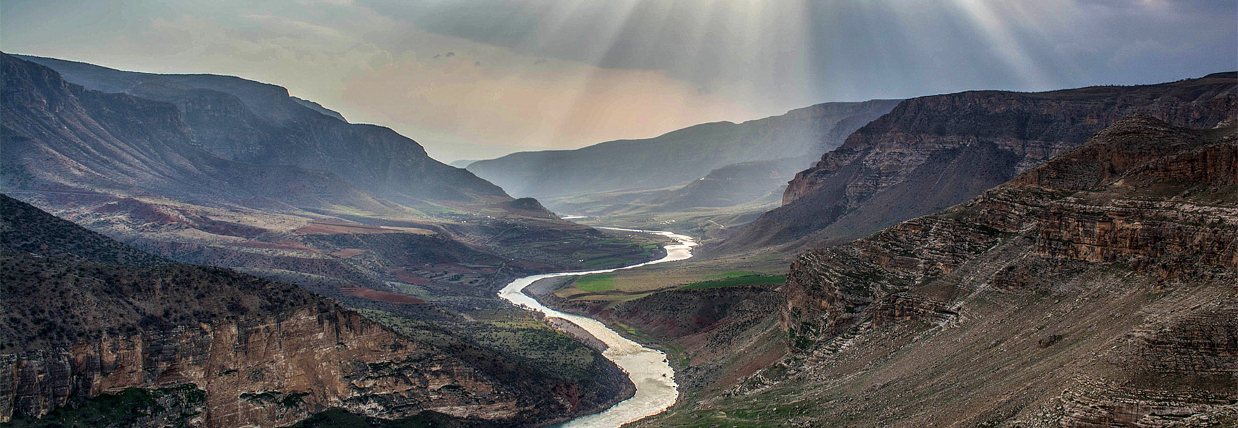
Born from the mountains to the west of Nordüz Plateau, and at the borders of Siirt-Hakkâri and Siirt-Van, the Botan River forms a deep valley through its route to west. This is called the Botan Valley. Starting from the mountains to the south of Bitlis province in the west, the Botan Valley passes between the 2741 meters high Doğruyol and 2631 meters high Mt. Kapılı, and goes into the Tigris Valley during its trip to south towards Siirt. Botan is one of the most steep and deep valleys of Turkey. Remains of human civilizations from Neolithic Era still survive at the Botan Valley, which was later used by the Greek armies during their march into Anatolia in 500 BC, known as "The Ten Thousand" in history, and located on the route of the Silk Road. Die Bildung von thermischen Luftströmungen in den Wintermonaten auf den 1000 Meter hohen Felshängen im Süden, Osten und Westen ermöglicht Flüge in 12 Monaten des Jahres.
This website is the product of two complementary projects. These projects, carried out by the Siirt based NGO Siirt’i Geliştirme ve Kalkındırma Derneği (Gelder), with the support of the Dicle Development Agency, are aimed at providing an opportunity for the development of Siirt by activating the ecotourism activities such as paragliding, hiking and mountain biking in the Botan Valley.
Within the scope of the projects, paraglider flight spots, hiking trails, bicycle trails were discovered in the Botan Valley and its wildlife was revealed in order to make the valley more attractive for tourists.
The 4 new paragliding spots in Botan Valley are waiting for you!
Located just 5 km from Siirt downtown, the paragliding spot is facing the spectacular scenery of the valley's widest section.
Located over an 860-meter steep slope next to Alkumru Dam, the paragliding is facing the most visited scenery of Siirt.
Located on a hill next to the Fisken village, the paragliding spot is especially suitable for paragliding pilots who would like to do soaring flights.
The two different take off points in the east and west direction at the spot makes it suitable for beginner and intermediate pilots.
The newly discovered 7 hiking and 3 mountain biking routes are waiting for you!
Starting near the gardens of Gokcebağ, the trail goes into a sparse forest before ending up over a bayou of Botan Valley.
It reaches to the 1180 meters peak of Botan where you can see the best scenery of the valley.
Though its age is not known, the Antik (Antique) Road is still used by shepherds and villagers between Gokçebağ and Botan River.
It is one of the 3 passes on the world still retaining its original stone tiles.
This steep trail is still used by the local people of Çınarlısu village to reach their gardens.
The 12 km route (2-ways) has been used for years by locals between Taşbalta and Çatılı villages.
The trail starts from the south of Taşbalta village and ends at a high spot with a scenery of Alkumru Dam's reservoir.
Different from the hiking trail, the route climbs to the highest point at the southern slope of the Botan Valley.
The route starts between Tillo and Çınarlısu village and ends at the top of a cliff seeing Botan Valley.
The 29 km long trail located between Taşbalta and Erenler villages goes along the Botan River.
The biking routes given at this website can also be used for hiking.
So that you can make your shopping from these villages. This will support the villagers. Try the tandour bread!
Although the highest point of the valley is at 1400 meters above sea level, it does not snow in many parts of the valley. The summers however are very dry.
Signs are found on the trails for your ease.
